


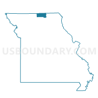
Liberty Voting District, Putnam County, Missouri
About
Outline

Summary
| Unique Area Identifier | 609489 |
| Name | Liberty Voting District |
| County | Putnam County |
| State | Missouri |
| Area (square miles) | 48.01 |
| Land Area (square miles) | 48.01 |
| Water Area (square miles) | 0.00 |
| % of Land Area | 100.00 |
| % of Water Area | 0.00 |
| Latitude of the Internal Point | 40.53023320 |
| Longtitude of the Internal Point | -92.80486130 |
Maps


Graphs
Select a template below for downloading or customizing gragh for Liberty Voting District, Putnam County, Missouri


Neighbors
Neighoring Voting District (by Name) Neighboring Voting District on the Map
- CALDWELL TWP Voting District, Appanoose County, IA
- Elm Voting District, Putnam County, MO
- Grant Voting District, Putnam County, MO
- Lincoln Voting District, Putnam County, MO
- Richland Voting District, Putnam County, MO
- WELLS TWP W/O MOULTON Voting District, Appanoose County, IA
Top 10 Neighboring County Subdivision (by Population) Neighboring County Subdivision on the Map
- Elm township, Putnam County, MO (579)
- Caldwell township, Appanoose County, IA (425)
- Lincoln township, Putnam County, MO (313)
- Wells township, Appanoose County, IA (270)
- Richland township, Putnam County, MO (259)
- Liberty township, Putnam County, MO (218)
- Grant township, Putnam County, MO (210)
Top 10 Neighboring Unified School District (by Population) Neighboring Unified School District on the Map
- Centerville Community School District, IA (9,212)
- Putnam County R-I School District, MO (4,843)
- Moulton-Udell Community School District, IA (1,466)